Who really matters in the world? Where do people who hold U.S. patents really live? Where and how intense have hurricanes been since 1851? How did science fiction come to be? What are the “battle lines” between the left and right sides of the political spectrum? How are verses of the Bible related to one another? Answers to complex questions like these are beautifully visualized in Places & Spaces: Mapping Science, exhibiting at the University of Miami beginning September 4.
This exhibition of 100 visualizations is intended to “inspire cross-disciplinary discussion on how to best track and communicate human activity and scientific progress on a global scale,” according to Katy Börner, curator of Places & Spaces and professor of Information Science at Indiana University. Börner pioneered Places & Spaces in 2005; since then, it has grown from 10 visualizations to 100 and has traveled throughout the United States.
“Data visualization is critical to our understanding of the world, and Places & Spaces presents data in an incredibly beautiful way, making it that much easier to grasp big picture and big data concepts,” said Sawsan Khuri, director of engagement for the UM Center for Computational Science. “We hope that this exciting exhibition will be a catalyst for creative, innovative data visualization work throughout all UM campuses.”
Places & Spaces is brought to UM by the Center for Computational Science (CCS), the College of Arts and Sciences, and the School of Communication. “Our goal is to transform the University of Miami into a major center for data visualization, info graphics, and information design in the southern United States,” said Alberto Cairo, assistant professor of professional practice at the School of Communication and director of the Visualization Program at the CCS. “Along with new initiatives to be launched, the Places & Spaces exhibit and lecture series will help us achieve this goal.”
“The study of data visualization crosses disciplines and has applications in a variety of academic areas,” said Thomas J. LeBlanc, UM executive vice president and provost. “Places & Spaces showcases the kind of cutting-edge work the University already has in progress at the School of Communication, the School of Architecture, the College of Arts and Sciences, and the Center for Computational Science.”
Half of the 100 visualizations will be displayed at the Stanley and Jewell Glasgow Hall on the first floor of the School of Architecture, which has its own visualization projects in progress. The other half, and all the 3D and interactive elements, will be on the first and second floors of the Richter Library.
Throughout the fall 2014 semester, world-renowned visualization designers and researchers will speak at UM about their work with big data and how it relates to Places & Spaces. All events are free and open to the public, but registration is required for many of them. More information will be available soon at the UM Visualization website.
Scheduled Special Events:
Thursday, September 4 – Opening Reception. Katy Börner, curator of Places & Spaces will speak. Stanley and Jewell Glasgow Hall, UM School of Architecture. 6-8 p.m.
Thursday, September 18 – Manuel Lima: Creative Visualization and Data Art.
Stanley and Jewell Glasgow Hall, UM School of Architecture. 6-7 p.m.
Monday, September 29 – Adib Cure, Carie Penabad and Chris Mader: Mapping Informal Cities. Stanley and Jewell Glasgow Hall, UM School of Architecture. 6-7 p.m.
Thursday, October 2 – Nela Ochoa, Xavier Cortada, and Patricia Van Dalen: How Science Inspires Their Art. CAS Wesley Gallery, 1210 Stanford Drive, 5:30 – 7:30 p.m.
Thursday, October 9 – Nigel Holmes: Humor in Visualization and Infographics.
Stanley and Jewell Glasgow Hall, UM School of Architecture. 6-7 p.m.
Thursday, October 23 – Stephen Few and John Grimwade: Visualization for Effective Communication. Stanley and Jewell Glasgow Hall, UM School of Architecture. 6-8 p.m.
Sunday, November 9 – Family Day in partnership with the Lowe Art Museum. Details TBA.
Thursday, November 13 – Ruth West: Cross-Resonance in the Arts and Sciences.
Richter Library, 3rd floor conference room. 6-7 p.m.
Monday, November 17 – Li Yi: Data Mapping and 3D Visualization with GIS. Stanley and Jewell Glasgow Hall, UM School of Architecture. 6-7 p.m.
Wednesday, November 19 – National GIS day. Otto G. Richter Library, 3rd floor conference room. 6-7 p.m.
Sunday, December 7 – Self-guided tours of the exhibit as part of UM’s Art Basel Breakfast. Details TBA.
Wednesday, date TBA – Claudio Silva: Visualization of Big Data. Department of Computer Science seminar. Ungar Building, Room 230, 5-6 p.m.
Thursday, December 11 – Closing Reception: Juhong Park, Alberto Cairo, speaker: Stanley and Jewell Glasgow Hall at UM’s School of Architecture. 6-8 p.m.
Annette Gallagher can be reached at 305-284-1121.
Image:
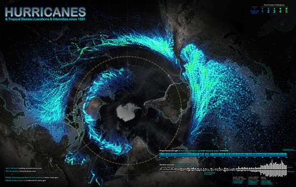
Nelson, John. 2012. Hurricanes & Tropical Storms—Locations and Intensities since 1851. Lansing, MI. Courtesy of IDV Solutions. In “9th Iteration (2013): Science Maps Showing Trends and Dynamics,” Places & Spaces: Mapping Science, edited by Katy Börner and Todd N. Theriault. http://scimaps.org.


